Friday, February 14, 2014

Existing Studies


I was reading that studies exist on regional rail transit in Cincinnati. The one the is most interesting is also 3000+ pages. I pulled a few interesting pages out for you below.

First, they evaluate a route similar to mine. I am not sure why they want to go through Evendale when they could go through Glendale, Wyoming and Tri County. My route is in pink below. They also proposed a route through West Chester. This is wrong, transit is for urban walk-able places. 


So what did they think? The route would get a 1000 riders a day.  This is crazy. They only expect 9 riders a day to the Dayton Airport. I have not had a chance to dig in and find the methodology error yet. For more realistic ridership numbers, check our Chicago's Metra daily ridership


With only 1,000 riders a day, their analysis concludes that the route would cost $54 a day per rider. If the ridership were something more realistic like 20,000 a day the operating cost would be $2.70 per rider. This is completely feasible.


It should be noted that the expected cost of these rail lines would be 1/5 the cost of an additional bridge. We should put it to voters - would you rather have five commuter rail lines or another bridge. 

Finally - just because I thought it was pretty: 


My Plan

My plan is to create a region tied together through transit. Cincinnati does not think of itself as connected to Dayton - but everyone else does because it is.

My has several parts and may take 20 years to implement. 
  1. Move I-75 west at the river into the flood zone freeing up space in downtown Cincinnati for transit oriented development
  2. Build transit connecting the region along the Mill Creek and Great Miami River
  3. Consolidate airports
  4. Connect I-71 to the new airport

Part 1 Move I-75 West
This is the focus of this blog because this has the most near term implementation. The point of this is to reverse some of the damage done in the 1960's. It also brings underutilized land into the urban core, allowing the city's central business district to grow. Few other cities have the opportunity to increase the acreage of the urban core like Cincinnati does.


Part 2: Build Transit connecting the region
Eighty percent of Ohio residents live in an urban area. That does not include Northern Kentucky, one of the more urban parts of that state. Historically, railroads went through urban cores because when they were built, that is where the factories were. Today, those rail lines still carry freight through the center of Cincinnati, Hamilton, Middletown and Dayton. However, several railroads wanted to service this route, so redundant lines run parallel to each other throughout the region. This leave the opportunity to consolidate service and free up lines for transit exactly where they are needed - in urban areas. It would connect the (newly expanded from pt 1) Cincinnati and Dayton convention centers. A major stop and only park and ride would be located at Tri County Mall. This would utilize the mall parking lot that sit empty much of the time - while people are at work.

Sorry for the messy map below. The line I am proposing is in yellow below.
Key 
Yellow: Proposed line
Red pins: Proposed stops (potential extension to Columbus)
Black: Existing Freight Rail Lines
Blue: Dead end existing freight lines
Pink: Rail spurs that would be impacted
Brown: New airport - keep reading
Orange: New highway


Part 3: Consolidate the Airports

Cincinnati gambled on Lunken Airport are the main airport for the region and lost. The resulted in CVG becoming the leading passenger airport and control of the airport in Kentucky's hands. Closing the DAY (Dayton) and CVG will not be cheap, but it is in the best long term interest of the region. In order to compete, an airport needs a strong base population. This is why OHare has continually gained flights while CVG has very noticeably lost them. Consolidation changes the region from one of 2 million people to one of 3.3 million. It also allows the region to connect the airport to transit and give control of the airport back to Ohio. This new airport would be located along the new transit route between Trenton and Hamilton.

Think of the economic impact this would have on Ohio. I don't see how Ohio politicians could resist.


Part 4: Connect I-71 

I talk a great deal about how bad highways are on this blog, but I am not totally against highways. Connecting I-71 near Kings Island to I-75 and the new airport will bring passengers from all over Ohio to the new airport.

This plan is an alternative to the Brent Spence addition for several reasons.

  • Less development in Kentucky means fewer people crossing the river
  • Fewer trips to CVG means fewer trips over the river
  • More transit along I-75 means fewer car trips
  • Transit serving the second street transit station would have strong connections to Northern Kentucky transit - reducing vehicles

Cincinnati + transit: not even trying

So I have been getting nervous lately because Kentucky seems to be getting their act together on the Brent Spence. Maybe I am generalizing too much, there are exceptions, but on the whole I would describe Kentucky as anti-urban.

I have a plan that is very different than that put out by OKI, the agency that determines most transportation funding in the region. My plan would increase transit ridership and urbanization. (see next post)  OKI's plan is not even trying. Lets look at it.

OKI's plan is for the number of people living near transit to decline by 9.2% from 713k to 647k. 

Source: OKI 2012 Transportation Plan, p. 41

OKI plans to achieve this goal by emptying out the City of Cincinnati.

Source: OKI 2012 Transportation Plan, p.6


How does this relate to the Brent Spence? The organization that leads planning for the region and determines what projects are eligible for federal money is not planning for an urban future. They are focused on getting more people from the suburbs to the suburbs. The additional* bridge next to the Brent Spence is often billed as a freight project, however the existing bridge - like most highways - is under utilized outside of commuting hours. The additional bridge is for commuters. 

If the region were to focus on increasing transit ridership and focus development on urban areas Cincinnati could make the halt to VMT growth permanent. While the project site only list documents back to 2005, initial plans for the BSB addition were done before that. The chart below shows how any forecast done before 2007 is going to over project highway demand. 


It is tough to be an urbanist in Cincinnati. You have to find a way to get OKI board members from Kentucky, Indiana and Butler County to agree to stop development in their areas to focus resources on the urban core. Not even the City of Cincinnati can agree with its self to to this. However, without this focus, the wrong infrastructure will be built. 
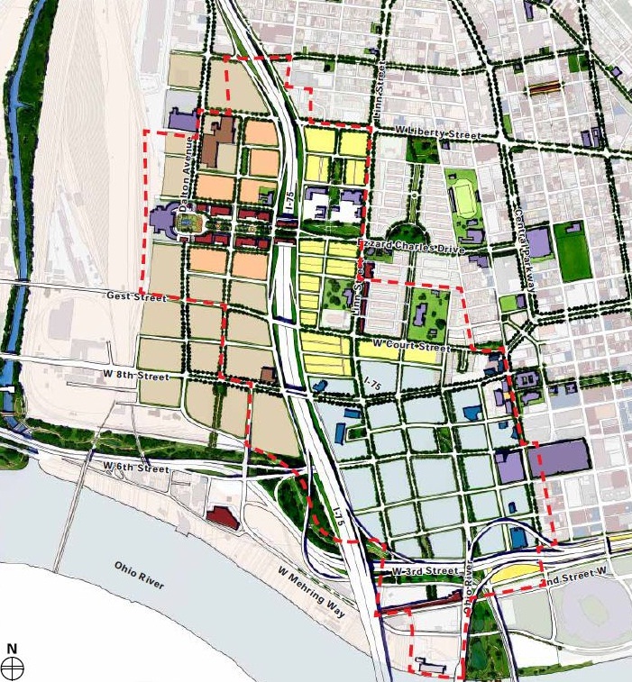
The additional BSB could be built in a way that frees up space in downtown Cincinnati. This plan was rejected because it displaces too many businesses and utility lines. I would hope that the leaders of the most expensive project in the regions history would have the courage to move a few power lines. The businesses that would be displaced are car dealerships and single story warehouses. These are not the kind of business that belong walking distance to the urban center. The region should demand that these business be relocated for under utilizing our precious urban space. There is no excuse for keeping the current rats nest of ramps adjacent to the central business district. 

Image: Urban Cincy / Revive I-75 study


Adding an additional bridge next to the BSB will be the noose that strangles downtown Cincinnati for the next 50 years. This is a now or never moment for downtown Cincinnati. 

Prior to the 1950's all transportation was funded based on property value impacts. Land developers would built transit because they wanted to increase property values. Local governments improved roads to improve local property values. When transportation funding became linked to the gas tax rather than property values, the goals shifted. Rather than making great places, transportation funding went to "reducing congestion". This means moving cars faster - a self perpetuating cycle that increases gas taxes. 

A breakdown in gas tax ( not increasing with inflation) has broken this cycle for and driven transportation funding back to local (or at least state) government. The people that are planning the additional bridge are once again linking the funding to the number of vehicles that drive. This has resulted in a configuration that maximizes vehicle movement while ignoring potential property values. The opportunity cost of not moving I-75 is nowhere in the equation. 

Lets review: 
  • OKI is not urban oriented
  • The Highway Trust Fund/ fuel tax is not urban oriented
  • The most expensive project in the Cincinnati urban core is about to happen
  • It is not urban oriented
Maybe this - drive less, back to the city - thing is a fluke that will fix itself once it is easy to drive again. That is what we want right?


See the next post for my alternative to the additional bridge for I-75. 

*I encourage everyone to refer the the Brent Spence Bridge project as an additional bridge as the current bridge that is soooo dangerous and at risk of falling down is not going anywhere under any plan. The engineers agree that it is in good enough condition to keep.